Ascending the trail, looking over at the quarry.

I knew, from my prepwork that there would be a cabin soon. I didn't really know what to expect. I actually figured it to be further in, for some reason imagined it on the other side of the trail, and envisioned something... less than it actually was. I was pleasantly surprised, when around the bend I happened upon the cabin foretold in the map's prophecy. I knew I had my spot for lunch. It was actually a little later than I anticipated eating, but that's mostly because it was further down the trail. Inside the cabin was a small shelf with a radio, some books, a logbook, a bench you could store or sleep on, and a loft where people could sleep. There was a folding chair against the wall, a pan under the bench, a number of mostly empty water jugs and more trash than I would have liked, though most of it was either in a box or in a bag.
As I enjoyed this stop on the trail so much, I'd like to go back sometime soon and spruce the place up. Park nearby, lug a 5gal waterjug or two in to refill the bottles, clean some of the trash out, maybe clean up the grill grates hanging on the side of the shack, replace the radio's batteries. Stuff like that. I enjoy leaving places better than I found them.
As I enjoyed this stop on the trail so much, I'd like to go back sometime soon and spruce the place up. Park nearby, lug a 5gal waterjug or two in to refill the bottles, clean some of the trash out, maybe clean up the grill grates hanging on the side of the shack, replace the radio's batteries. Stuff like that. I enjoy leaving places better than I found them.
Lunch was a Mountain House chili mac. First variety I had ever tried, and of the ones I was carrying, I liked the sound of that the best. I set up my Canister Stove in the firepit and set 16 ounces of water boiling. I produced my kindle from my bag and read while I waited for water to boil, then for the food to rehydrate, and continued reading as I ate. Once again a Sea To Summit aircraft aluminum spoon was able to save my knuckles from the worst of the bag's mess. I could have made camp there and been pretty happy, but I was down to roughly 20% of my water after lunch, and I knew I'd be able to filter at the Waupaca River if I kept going.

I didn't take the depicted Scenic Loop, I went left there but it rejoins the trail at the Waupaca River. I'd envisioned the river being further away, larger and deeper, and for some reason had pictured the point where it met as being some sort of bridge. What it actually was, was a pleasant looking large creek. Private land lay on the other side of the river, and I suspect that they've had issues with trespassers before, because the signage was quite dense along here. Upon spotting the river, I took my first opportunity to climb down and filter some water. It looked a nice place to do it, on the outside of a bend in the river, water moving along nice and clear. The bottom was kinda muddy though, and I was really glad for my Prefilter. If you're looking at the MSR Sweetwater and wondering "do I get a prefilter?" Yes. Get the prefilter. $20 will seem trivial when you see how much grief it saves your filter element.
As I'm pumping up my camelbak, and looking across the bend at the chairs and no trespassing sign left there by the owners of the opposing shore, I hear a thundering boom ring out. I ducked down, shielding myself with the earth of the riverbank, looking around. I knew there were a lot of "no tresspassing signs" but I was right on the side of the trail, surely somebody wasn't trying to scare me off with gunfire were they? As I resumed pumping, there it went again, another thunderous boom.
The reports were too infrequent to be gunfire, I thought. And they were a little strong for it too. Then I remembered what I passed on my way in. A Quarry. I decided they must be blasting.
Another note on the MSR Sweetwater. I chose this filter because unlike the lighter Sawyer Mini or the easier to filter with Platypus Gravityworks, the Sweetwater is at least somewhat capable of filtering out harmful chemicals. It's still VITAL to filter your water from good sources, and in part I feel this means large sources such as lakes, and when I can, moving sources like the small river I filtered from. In addition to the Sweetwater, I have a second line of defense on my camelbak. It's nothing I'd want to rely on on its own, but there's a carbon filter element you can snap into the hose line and it'll clean up the taste of your camelbak's water. I figure that despite it's disclaimers, it also makes a decent secondary filter incase there was something, chemically, in that water that I didn't wanna be drinking.
Why is this a concern, you ask? Well, most of the hiking-oriented filter products are aimed at hikers on one of the bigger scenic trails, the AT, PCT or CDT, which travel on average, wilder terrain than the IAT does. You could hardly swing a trekking pole on my hike without pointing it at some farm in the distance. Farms, mean fertilizer and pesticide. and even though the water of the Waupaca River was clean and clear and didn't show evidence (such as smell, or abundant algae) that it was a bad place to drink from, I'm sure some runoff from the many miles that river winds, was present in the water flowing by.
In my time estimate, I'd completely forgotten to account for the time it'd take me to filter my water there. So as I hit the trail again, I was a little behind schedule, if we went by the strict guesses on my itinerary. As I continued down the trail, I saw to my dismay that in my excitement to get water, I had chosen the least convenient place to filter at. If I had walked 5 minutes further, I could have sat nearly at river level and filtered from a clean sandy riverbed. Oh well, lesson learned. Next time I'll walk on for 5-10 minutes and if I don't see anything better, backtrack to where I first happened upon a water source.
Refueled and Refreshed, I found it easy hiking to continue onwards, and it was not long before I reached a point where I could choose a blue side-path to reach the Cobbtown parking lot. Now, up until this point, I hadn't seen a single person on the trail. Not when I stopped for lunch, not when I heard that unholy howl, not since Bob dropped me off in the morning. And I still didn't exactly encounter anyone. Now, it WAS a tuesday in late spring... I'm sure that's far from Peak Hours for the Ice Age Trail. But I did see a car pull into the lot from across a meadow. And I saw its occupants regard the signage at that lot. I continued on, and I believe they must have gone northbound, because I never saw them again. I also saw several cars in the lot, but could NOT tell you where their drivers had gone.
Shortly after encountering the lot, I wound my way to the end of the proper trail. It ends at the Cobbtown drive bridge over the Waupaca river. If you ask me, this is really the end of this section of trail, and the connecting road is a formality. You follow Cobbtown drive to Townline Drive, and walk up Townline Drive. Yes. Up.
Up.
Lucky for you, we can do this the quick way. Looking back at that climb?

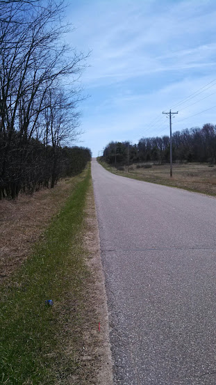
This was the worst part of the trail. 2.7 miles of paved road. The Tree Farm to the left was ADAMANT that no one tresspass in it's land. Shame, because it would have been super easy for them to run the trail parallel to the road, and at least give me a bit of shade. I think this is the part of the walk that was hardest on my feet, and what would wind up screwing me over for the last leg of the trip. I can't decide what was worst, that there was nowhere to stop and rest (all private property), or that my feet got all ground up by the hard asphalt and gravel. About halfway there IS a little shade, but nowhere to sit. Did I mention I would have liked to stop and sit? Because I woulda loved to sit. Love my camelbak though. Soooo glad I had that.
Finally! Something that wasn't road!

Approaching Highway 54, we go left into a farmer's field, and walk along the line of irrigation equipment there. Beware of gopher holes because there are a network of marmot tunnels here big enough in places to take my entire leg and have room for whatever rodent burrowed them to climb up it and into the field. I wanted to make the treeline across the field before I stopped to change socks, but about halfway across, I noticed my boot had come untied. I took this for a prompt to stop. But, shitty luck prevailed. Literally. I was about to sling off my pack and set it down when I spotted some dog doo right where I was going to set it. Moved about 10 yards down, and wouldn't you know it? the exact same sequence replayed itsself. It was almost a glitch in the matrix.
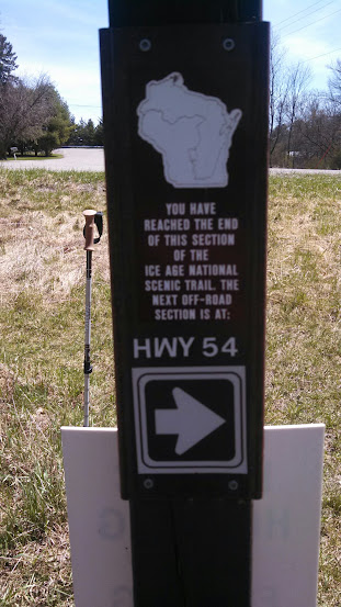
Third time was a charm and either there was no poo, or I sat in poo that I didn't see. Traded one pair of socks for the other and started on my chocolate brownie Clif bar. It wasn't long until the trail brought me to the lot along Highway 54. Technically this, was part of the waupaca river segment, though I'd be tempted to call it part of the Hartman Creek segment.
Here, a sign heralded that it was only 3 miles to the HCSP Campground. I took it as a good sign. I crossed Highway 54 and started into the final leg of my trip!
Here, a sign heralded that it was only 3 miles to the HCSP Campground. I took it as a good sign. I crossed Highway 54 and started into the final leg of my trip!
No comments:
Post a Comment